
Search Lake Jackson Streets
A street-by-street search begins with a single property location, not a guessed household list. The Brazoria Central Appraisal District, known as BCAD, can connect a street number and street name to an appraisal account. The County Tax Search is a separate route for actual property location, owner name, owner mailing address, and account records. Each result is a record lead. It may identify an owner or a mailing contact, while current occupancy can remain unshown or protected.
- Enter the address in the BCAD Property Search with the street number and normalized street name. Record the property ID or geographic ID if one appears.
- Open the BCAD Interactive Property Map to compare the parcel position with nearby parcels. County GIS layers can add roads, address points, political boundaries, and floodplain context.
- Use the property ID, legal description, subdivision, and instrument date to search the County Clerk’s real-property route. Keep the volume, page, or instrument number with each result.
- Request a copy or ask the Clerk for help when an online image is redacted or unclear. The index is a finding aid, not the final official record.
- For a past listed household, check historical newspapers and telephone directories, then validate the address against the parcel and Clerk record. No official public Lake Jackson street-level voter roster was located.
The chain is address to parcel, parcel to legal description, and legal description to recorded instruments. It can show a property trail. It does not turn into a verified list of every person on a road.
Note: Preserve the search date with each result because tax, map, and recorded data can change at different times.
Lake Jackson Street Tokens
Lake Jackson is not a simple numbered grid. City history describes a master plan by Alden B. Dow that preserved trees and used curved drives. Center Way is central, Circle Way circles the business district, and the city includes the unusual names This Way and That Way. That street pattern makes exact search tokens important. A search that assumes every road has a predictable direction or a standard grid position can miss the record it needs.
Try the core name and a careful abbreviation variant when a portal allows it, such as Dr and Drive, St and Street, or Way. Do not combine an old and new address merely because they look similar. The city found no official evidence of a citywide renumbering or renaming event. For historic work, City Secretary archives, annexation files, and USPS address confirmation are the appropriate places to verify a claimed address change.
City history identifies Oak Drive as the first street carved and places the first family on Trumpet Vine Street in January 1942. Those are useful terms for map or newspaper research, not evidence of current residence.
Note: Exact street tokens are especially important when a road name includes a drive or way rather than a directional grid label.
Lake Jackson BCAD Street Fields
The BCAD Property Search exposes address and parcel controls that make it the strongest starting point for a Lake Jackson street directory search. Use the least amount of information needed to narrow a result. BCAD instructs users to enter the Street Name without a prefix, suffix, or unit number. Owner name uses the Last Name First Name pattern. A property ID or geographic ID is more exact when it is already known.
| BCAD control | Entry rule | Street research use |
|---|---|---|
| Street Number | Number only | Narrows a particular situs address. |
| Street Name | Omit prefix, suffix, and unit | Normalizes a Lake Jackson street search. |
| Property ID | Exact identifier when known | Provides the strongest appraisal-account retrieval. |
| Geographic ID | Exact identifier when known | Supports a parcel and map cross-check. |
| Tax Year | Portal-rendered options | Allows comparison where an available year is relevant. |
| Subdivision | Autocomplete and search | Helps place a parcel in platted neighborhood context. |
BCAD also displays owner, abstract, property type, neighborhood, condo, mobile-home-park, protest, and hearing controls. The landing page did not establish archival depth, export options, result columns, or a current-data date. Its notice says the information is for research and that legal descriptions and acreage should be verified. An appraisal value is not a survey, a title opinion, or proof of occupancy.
Lake Jackson Address Records
Several public systems can be searched by address or then connected back to an address. They have different purposes, dates, and access paths. The table separates what an address-keyed record can establish from what it cannot. It also keeps a property owner, a mailing contact, a parcel boundary, and a current resident from being treated as the same thing.
| Address record | Custodian | Useful connection | Access channel |
|---|---|---|---|
| Appraisal account | BCAD | Property ID, geographic ID, legal description, and appraisal research | Online property search; mapping help by phone or email |
| Tax account | Brazoria County Tax Office | Actual property location, account, owner, and mailing-address search paths | Online County Tax Search; Lake Jackson branch or Angleton office |
| Parcel and boundary layers | BCAD and County GIS | Parcels, address points, roads, political boundaries, and floodplain | Online viewer, REST services, or GIS data request |
| Recorded real property | Brazoria County Clerk | Instrument dates, grantor-grantee trail, and copy request references | Online landing page, public computer, Clerk counter, or copy request |
| Permit or code record | City department | Dated city record if one exists and is releasable | Precise Texas Public Information Act request |
A situs address is the physical property location used in appraisal and tax contexts. It is not necessarily the owner’s mailing address or evidence that an owner lives there. This distinction matters when comparing a BCAD result with a tax-account result or a later recorded document.
Lake Jackson Parcel Boundaries
The Brazoria County GIS and its official REST services provide a second location check after BCAD. Available service categories include Address_Points, Parcels, Roads, Political_Boundaries, Floodplain, Legal_and_Development, and community features. These layers are useful when a Lake Jackson street is near an edge, a drainage feature, or a municipal boundary. They do not replace a survey or a legal boundary determination.
BCAD’s mapping handbook says downloadable GIS data is updated monthly and describes parcel/account, roads, divisions, owner, situs/state-code, improvement, and district layers. The map interface itself did not yield a confirmed toolbar or popup-field list in the research capture. Clicked map information should therefore be checked against the appraisal record, recorded instrument, or the appropriate custodian before a reader relies on it.
- Parcel
- A mapped unit of land associated with an appraisal or tax account. A parcel is not a statement of current occupancy.
- Situs address
- The physical location of property used for record matching, distinct from an owner’s mailing address.
- Plat
- A recorded map that lays out lots, blocks, streets, or a subdivision. It helps place a legal description on the ground.
- Criss-cross directory
- A historical directory arranged by address rather than personal name, useful as a dated listing rather than present-day proof.
Lake Jackson Property Locations
The County Tax Search keeps two address ideas apart. Its instructions say the owner address is the mailing address, while the property location is the actual address. For a Lake Jackson street directory query, use the actual street number and name when looking for the property location. The tax search also says to omit the street type and direction. A search for an owner’s mailing address answers a different question and may point outside the city.
Its visible controls include a Search-by menu, text field, Account Type, Include Inactive Accounts, Pay Status for both, paid, or unpaid, and a Search button. The research did not capture a result schema or coverage date, so do not assume an empty response proves a property does not exist. Try the normalized address and then the BCAD property ID route. When an address remains unclear, the Clerk, BCAD mapping staff, or Tax Office can identify the correct record procedure.
A County Tax Search screen shows the separate choices used to locate a tax account.
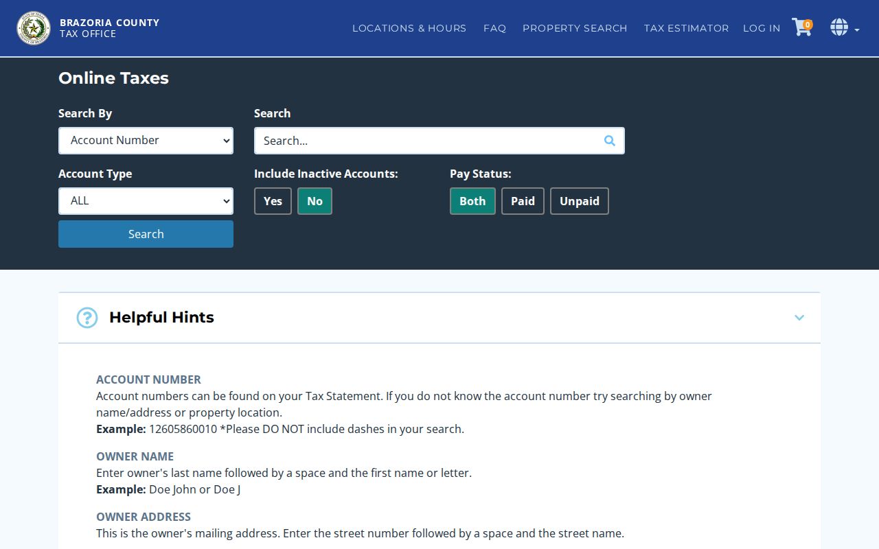
The screen supports an address-led check, while the surrounding record trail still requires verification with BCAD and the Clerk.
Note: A mailing address can be useful for correspondence history, but it should never be presented as a verified Lake Jackson residence.
Lake Jackson Deed Trail
Once an address has a parcel or legal description, the Brazoria County Clerk’s real-property system can supply the next trail. Start at the real-property search landing page, then work from the current parcel ID or geographic ID to the legal description, subdivision, instrument date, and grantor-grantee chain. A grantor gives an interest in a recorded instrument, while a grantee receives it. Record the volume, page, or instrument number before moving to an earlier document.
The external online system requires first-time users to create a login and verify an email address. It is not operated by the Clerk, and the county warns that online images may be redacted or may not be complete or unaltered. For copies, the County Clerk has a separate real-property search and copy request process. It lists $1 per page for copies and $1 per page plus $5 per document for certified copies. Certified copies are mailed by regular mail only.
The Lake Jackson Annex Real Property Records Office is at 202 Peach Street, Room 103, and the main recording office is in Angleton. The Annex lists weekday hours of 8:00 to 4:30, with lunch from noon to 1:00. Beginning January 1, 2026, the Clerk’s notice says a person presenting a real-property record in person must provide photo ID under Texas Local Government Code §191.010. Confirm the notice before a visit.
Note: A recorded deed can show a documented property interest, not a complete statement of everyone who lived at the address.
Lake Jackson Street History
Street research gains depth when the city’s own timeline is kept beside the parcel trail. Construction began in December 1941, the first family arrived in January 1942, the Oak Wood Project had 200 units in 1943, and Lake Jackson incorporated in March 1944. That sequence explains why an older county deed, tax roll, or map can predate the municipal record path for the same area.
The Lake Jackson Map Gallery includes city limit and ETJ, zoning, subdivision, park, flood, and annexation maps. Its annexation material shows additions in 1981, 1990, 1993, 1994, 1996, and 2006, including local areas such as Jackson Oaks and Timbercreek. A property’s municipal status may therefore differ across dates. The map gallery warns that maps can be inaccurate, so contact Engineering for a decision that depends on a boundary.
For a historic address lead, the Lake Jackson Historical Association collection offers digitized Lake Jackson News material, and the Texas State Library and Archives Commission holds older county microfilm. The historical city-directory collection is described separately in the Lake Jackson city directories resource. Those dated sources can support a carefully labeled historical listing, but they should not be stretched into a current street roster.
Lake Jackson Records Requests
Some street records are not searchable online. A dated permit, code, inspection, annexation, or administrative map file may require a request for an existing document. The City of Lake Jackson accepts public-information requests through the City Secretary by email, mail or in person at 25 Oak Drive, and fax at 979-297-8823. A request should name the department, date range, address, and record type. It should ask for an existing record rather than an answer or new research.
The city says an itemized estimate comes before work that exceeds $40, and its published standard copy rate is $0.10 per page, with media and specialty charges varying. For county material, use the Texas Public Information Act with a precise description. The county’s guidance says the law does not require staff to answer questions or conduct legal research. Engineering can also route a county GIS data request; the request asks for contact details, organization, preferred format, and geographic extent.
Online access is only one route. BCAD, tax, GIS, and the Clerk system are useful first stops. The Lake Jackson Annex and Angleton offices provide in-person options. Clerk copy requests can be completed through the separate payment process, while BCAD mapping staff, the Clerk, and museum or library research channels can help identify a records custodian. Historic deeds, tax rolls, maps, and newspapers also have TSLAC, library, and museum paths.
Lake Jackson Street Limits
A Lake Jackson street directory cannot reveal every person at every address. No official open street-by-street resident list was found. The state voter registration route is not the same as a public street-name search, and protected fields are not available for publication. An appraisal account, tax record, or telephone listing may link a name to a property or a past listing, yet that is not proof of present occupancy.
Texas has address-confidentiality protections, including the Attorney General’s Address Confidentiality Program and voter-address confidentiality rules. Do not seek, repeat, or infer protected residence information. Use public material for a specific, lawful personal purpose, preserve the source and date, and take an uncertain match back to the office that owns the record.
Lawful use. Lake Jackson address records support careful personal research, not surveillance. Do not use a street, parcel, or record trail to stalk, harass, intimidate, or harm anyone.